
+- IDU Regional Forum (https://idugov.com/forum)
+-- Forum: Cultural Center (https://idugov.com/forum/forumdisplay.php?fid=98)
+--- Forum: Cartography, Vexillology, and Historiography (https://idugov.com/forum/forumdisplay.php?fid=6)
+--- Thread: IDU Ministry of Cartography 2022 Map (/showthread.php?tid=2050)
RE: IDU Ministry of Cartography 2022 Map - Sanctaria - 03-15-2023
Nation Name: Buckingham
Nature of request: • Puppet Nation, First Time Placement
Which continent would you like to be located? Please see photo (Hespirida)
Which side of the continent? Please see photo
Which Nation(s) will share a border with you? Zhonrey
Which features are characteristic of your Nation? (As many as apply)
• Rocky Coastline/Fjords
• Natural Bay/Harbor
• Jagged borders
Which color would you prefer on the Political Map?
• Light blue
RE: IDU Ministry of Cartography 2022 Map - Haesan - 04-09-2023
Nation Name: Haesan
Capital City: Hwagang
Describe location of capital city within the nation:
This is somewhat complicated due to the nature of this request and is further explained below
Nature of request: (Please select from these options)
This is a 3 in 1 request (in order of importance):
1. Primary/Main Nation, First Time Placement
2. Nominate a Nation for Removal
3. Already On Map, Requesting Modification
Which continent would you like to be located? (Please select from these options)
• Hesperida
Which side of the continent?
• East
What Approximate Latitude?
Unknown.
Which Nation(s) will share a border with you?
Borders Laeral (Xueyan SAR) to the west, Lao Sangsong to the north, and Byzconia to the east.
I have received confirmation over Discord from both Laeral & Lao Sangsong (Slokais) for this plan. I have made a good faith effort to contact Byzconia, but have not heard a response.
Which features are characteristic of your Nation? (As many as apply)
Haesan has a smooth, easily navigable coastline. A large mountain range is found in the far west, Starting in North Soeyan (Xueyan SAR), and cutting down all the way south to the coast of the Albarine Sea. A smaller mountain range cuts east-west through the western half of Haesan, bisecting the two (as yet unnamed) lakes. The central and eastern portions of Haesan are fairly riparian, with cities mainly forming along coasts and in river valleys.
Which color would you prefer on the Political Map?
• Lavender
What real-life nation has characteristics similar to your nation in terms of size, location, geography, or culture?
South Korea, culturally.
Is there anything else you would like the Ministry of Cartography to know?
The second request, a bit unusual due to the circumstances of the upcoming map redesign, is a claim of Byzconia's territory in the case that they fail to meet the requirements to remain on the next map. This additional claim would also include the island circled in the map below. The Slokais Islands, the only other nation who has a potential geographic claim to Byzconia's territory, has approved of this plan.
The third request, is to indicate that the so-called "Xueyan SAR" is a disputed territory claimed by Haesan but administered by Laeral. Laeral has acknowledged that we dispute the territory, and gives the ok for it to be acknowledged as such. This can be done at the mapper's discretion.
Here is the link to the annotated map: https://imgur.com/Jg78QEI
The area outlined in black is the initial claim of Haesan. The red dot on the large lake is the capital placement we would like if the Byzconia claim fails. The red dot on the river border with Byzconia is the capital placement we request if the merger succeeds. The purple striped area to the east is our request for the Byzconian territory, along with the unclaimed circled island. The purple striped area to the west is the Laeralian controlled territory we dispute.
Thank you, and if anything is unclear, I would be more than happy to provide clarification.
-Haesan
https://imgur.com/Jg78QEIY
RE: IDU Ministry of Cartography 2022 Map - Greater Acadia - 05-06-2023
Nation Name: Eïkangärd and Tsimdaupohwetosonghnee
Capital City: Västergäd and Inwaukosuwuk respectively
Describe location of capital city within the nation: Please see attached image
Nature of request: Puppet Nation, First Time Placement
Which continent would you like to be located?: Liberalia
Which color would you prefer on the Political Map?
Eïkangärd: Light Blue
Tsimdaupohwetosonghnee: Lavender
Claim: https://imgur.com/a/bKaripi
Thank you very much for your consideration of my puppet placement. Please let me know if you need any further information.
RE: IDU Ministry of Cartography 2022 Map - Novella Islands - 05-19-2023
I would like to request the following amendments to both the Novella Islands, and to Opthelia, please.
Before.
After.
This will make the Novella Islands appear as the correct size, and will increase the borders of Opthelia to a more appropriate size.
Thanks in advance!
RE: IDU Ministry of Cartography 2022 Map - Doatia - 06-10-2023
Nation Name: Doatia Capital City: Doatia City Describe location of capital city within the nation: Large city on an island in the center of a lake, which is at the center of the nation
Nature of request: (Please select from these options)
• Primary/Main Nation, First Time Placement
Which continent would you like to be located? (Please select from these options)
• Caxcana
Which side of the continent?
Southwest
What Approximate Latitude? __________. Which Nation(s) will share a border with you? None (Please have them confirm their consent by replying with "OK" on this thread) __________
Which features are characteristic of your Nation? (As many as apply)
• Single Island
• Medium Land Area
• Riparian (many rivers)
• Peninsula
• Lakes
• Natural Bay/Harbor
• Jagged borders
Which color would you prefer on the Political Map?
• Peach
What real-life nation has characteristics similar to your nation in terms of size, location, geography, or culture? In size, nation is close to France. Mountains along the northern border. A central lake with several rivers splitting out of it and twisting across the nation, connecting to the ocean and/or smaller lakes, with the capitol center in the center. Is there anything else you would like the Ministry of Cartography to know? __________
Not sure how to describe it, but there is a piece of land that kinda breaks off from Caxcana in he southwest, above "Deebeeland". I'd prefer natural borders, such as mountains or rivers. Thank you!
RE: IDU Ministry of Cartography 2022 Map - Mattheland - 06-23-2023
Nation Name: Mattheland Capital City: Harnak
Describe location of capital city within the nation: Southwestern interior along a river that leads to west coast bay
Nature of request: (Please select from these options)
• Primary/Main Nation, First Time Placement
Which continent would you like to be located? (Please select from these options)
• Liberalia
Which side of the continent?
• North
• West
What Approximate Latitude? See map insert below
Which Nation(s) will share a border with you? (Please have them confirm their consent by replying with "OK" on this thread) None
Which features are characteristic of your Nation? (As many as apply)
• Smooth Coastline
• Rocky Coastline/Fjords
• Medium Land Area
• Riparian (many rivers)
• Lakes
• Natural Bay/Harbor
• Jagged borders
Which color would you prefer on the Political Map?
• Pink
What real-life nation has characteristics similar to your nation in terms of size, location, geography, or culture? Alaskan culture and geography, not as big location. Larger native Inuit population with Anglo/Scot/Irish influence
Is there anything else you would like the Ministry of Cartography to know? The west coast and Southwrst interior will be the most developed part of Mattheland, the north and east to be more sparsely populated.
Map

RE: IDU Ministry of Cartography 2022 Map - Lauchenoiria - 06-23-2023
Nation Name: Yesteria
Capital City: Northport (capital town; no cities in the country)
Describe location of capital city within the nation: top north-west point of top island
Nature of request: (Please select from these options)
• Puppet Nation, First Time Placement
Which continent would you like to be located? (Please select from these options)
• Neria
Which side of the continent?
• East
What Approximate Latitude? Island here: https://imgur.com/676F14n
Which Nation(s) will share a border with you? None
Which features are characteristic of your Nation? (As many as apply)
• Two Islands (upper mostly agricultural land; lower mostly forest)
• Small Land Area
Which color would you prefer on the Political Map?
• No preference
What real-life nation has characteristics similar to your nation in terms of size, location, geography, or culture? None in the present-day; it is a nation of primitivists who, during the industrial revolution, had a political revolution by peasants who then banned all technological advancements from that point onward. So basically the culture is more 1700s than any present-day nation. Except they are fully aware that other people have the technology, they just ban it from entering their country.
Is there anything else you would like the Ministry of Cartography to know? Thank you for indulging my puppet madness!
RE: IDU Ministry of Cartography 2022 Map - Gardavasque - 07-05-2023
(05-06-2023, 03:53 PM)Greater Acadia Wrote: Nation Name: Eïkangärd and Tsimdaupohwetosonghnee
Capital City: Västergäd and Inwaukosuwuk respectively
Describe location of capital city within the nation: Please see attached image
Nature of request: Puppet Nation, First Time Placement
Which continent would you like to be located?: Liberalia
Which color would you prefer on the Political Map?
Eïkangärd: Light Blue
Tsimdaupohwetosonghnee: Lavender
Claim: https://imgur.com/a/bKaripi
Thank you very much for your consideration of my puppet placement. Please let me know if you need any further information.
Thank you for your request; this will be included in the next map release (1-2 weeks). I'm happy to place your puppets on the map as you have described, however, could you be sure to create your puppets in the game and move them into the IDU first? The map is intended to facilitate role play among IDU nations. Thanks in advance.
RE: IDU Ministry of Cartography 2022 Map - Gardavasque - 07-05-2023
(06-23-2023, 12:26 AM)Mattheland Wrote: Nation Name: Mattheland Capital City: HarnakThank you for your request. It appears you have moved your nation out of the IDU. Since our map is to facilitate role play among IDU nations, the Ministry of Cartography will respectfully place your request on hold for now. We will be happy to reactivate your request in the future if you return. Best wishes to you.
Describe location of capital city within the nation: Southwestern interior along a river that leads to west coast bay
Nature of request: (Please select from these options)
• Primary/Main Nation, First Time Placement
Which continent would you like to be located? (Please select from these options)
• Liberalia
Which side of the continent?
• North
• West
What Approximate Latitude? See map insert below
Which Nation(s) will share a border with you? (Please have them confirm their consent by replying with "OK" on this thread) None
Which features are characteristic of your Nation? (As many as apply)
• Smooth Coastline
• Rocky Coastline/Fjords
• Medium Land Area
• Riparian (many rivers)
• Lakes
• Natural Bay/Harbor
• Jagged borders
Which color would you prefer on the Political Map?
• Pink
What real-life nation has characteristics similar to your nation in terms of size, location, geography, or culture? Alaskan culture and geography, not as big location. Larger native Inuit population with Anglo/Scot/Irish influence
Is there anything else you would like the Ministry of Cartography to know? The west coast and Southwrst interior will be the most developed part of Mattheland, the north and east to be more sparsely populated.
Map
RE: IDU Ministry of Cartography 2022 Map - Lauchenoiria - 07-06-2023
In the event that the request in this post is accepted
(05-19-2023, 11:48 AM)Novella Islands Wrote: I would like to request the following amendments to both the Novella Islands, and to Opthelia, please.
Before.
After.
This will make the Novella Islands appear as the correct size, and will increase the borders of Opthelia to a more appropriate size.
Thanks in advance!
Then I wish to submit the following puppet claim:
Nation Name: Glanainn
Capital City: Craobhaig
Describe location of capital city within the nation: (Example: Southwestern coast at mouth of the river) where the middle river meets the coast
Nature of request: (Please select from these options)
• Puppet Nation, First Time Placement
Which continent would you like to be located? (Please select from these options)
• Liberalia
Which side of the continent?
• North
• East
What Approximate Latitude? here: https://imgur.com/FFt4tUh
Which Nation(s) will share a border with you? (Please have them confirm their consent by replying with "OK" on this thread) Opthelia
Which features are characteristic of your Nation? (As many as apply)
• Rocky Coastline/Fjords
• Medium Land Area
• Lakes
• Natural Bay/Harbor
• Mountains
Which color would you prefer on the Political Map?
• No preference
What real-life nation has characteristics similar to your nation in terms of size, location, geography, or culture? Scotland (specifically the Highlands)
Is there anything else you would like the Ministry of Cartography to know? __________
RE: IDU Ministry of Cartography 2022 Map - Wosteaque - 07-06-2023
Nation Name: Wosteaque Capital City: Wostmage
Nature of request: (Please select from these options)
• Already On Map, Requesting Modification https://imgur.com/gallery/idfJbnd This would better reflect the biomes that are on each island.
Which color would you prefer on the Political Map?
The same color as Novella Islands.
Nation Name: Teyè Capital City: Loba
Nature of request: (Please select from these options)
• Puppet Nation, First Time Placement
Which continent would you like to be located? (Please select from these options)
• Neria (https://imgur.com/gallery/VarkhN9) Like this
Which side of the continent?
• East
Which features are characteristic of your Nation? (As many as apply)
• Smooth Coastline
• Archipelago
• Medium Land Area
• Riparian (many rivers)
• Peninsula
• Lakes
• Natural Bay/Harbor
Which color would you prefer on the Political Map?
• Lavender
RE: IDU Ministry of Cartography 2022 Map - Laeral - 07-07-2023
I was reviewing some of the nations scheduled for transfer to Meridia, and it appears that a number of them are puppets of active players which are still intended for IDU RP, even though the NS nations may have CTEd and been refounded elsewhere. For instance, Mallacaland and Lao Sansong are both puppets of Slokais's which are the subject of ongoing RP (as seen here: https://media.idugov.com/2023/06/11/mallacaland-and-lao-sansong-react-to-lidun-membership/) and have histories intertwined with neighboring nations, and so I'd like to suggest that they be kept in their current locations rather than be relocated to Meridia. Here's the nations that I spotted falling under this category:
- Bjeorg (puppet of LOM's, important to LOM's historical RP)
- Iskiram (puppet of Shuell's, important to Shuell and Serriel's RP)
- Lao Sansong (puppet of Slokais's, involved in RP)
- Mallacaland (same as above)
- Mansilla (puppet of LOM's)
- Shuell (active on Discord)
RE: IDU Ministry of Cartography 2022 Map - Democratic Republic Of Eiria - 07-16-2023
Nation Name: Eiria
Capital City: Geminus
Nature of request: (Please select from these options)
• Already On Map, Requesting Modification
Hello! Would it be possible to expand Eiria's size a bit on the new map? Eiria's canonical land area is a bit larger in character than the map reflects, so I was wondering if that would be a possible edit that could be made with the new map. If not, don't worry! Thanks for all your hard work on the map!
RE: IDU Ministry of Cartography 2022 Map - Khasar - 07-16-2023
Nation Name: Khasar, Capital City: Valerios, the city is located off the Western coast at the end of an inlet
Nature of Request: Primary Nation, First-Time Placement
Continent: Neria
Side: West
Features: Rocky Coastline, Fjords, Large Land Area, Tropical Northern Half, Desert Southern Half, Peninsula, Natural Bay, Jagged Borders
Color: Lavender
Real-Life Nation: This country is similar to India in terms of size, culture, and ecology and similar to Saudi Arabia in terms of location and geography
Additional Facts: Khasar is a sizeable nation with over 5.7 billion residents, so it needs adequate land. Khasar is in the top 5% of countries in Most Beautiful Environments due to the nation's lush forests filled with Tigers, the national animal. Due to the biome split of the nation (forests in the North, deserts in the South), many of the country's largest cities are located in the Northern region while the South houses more industrial and military institutions. Due to the country's reliance on the IT, Retail, and Arms Manufacturing industries and its lack of mountains and mines, Khasar has numerous harbors and a capable train system to constantly import and export necessary metals and materials.
Location on Map: https://imgur.com/a/rzkgAWb
RE: IDU Ministry of Cartography 2022 Map - Slokais - 07-24-2023
Nation Name: The Nuiqsut Confederation, Capital: Port Nuiqsut
Nature of request: (Please select from these options)
• Puppet Nation
Which continent would you like to be located? (Please select from these options)
• Neria https://imgur.com/a/ileusZI
Which side of the continent?
• South
Which features are characteristic of your Nation? (As many as apply)
• Medium Land Area
• Riparian (many rivers)
• Peninsula
• Lakes
• Natural Bay/Harbor
Which color would you prefer on the Political Map?
• Blue
RE: IDU Ministry of Cartography 2022 Map - Lehvant - 07-24-2023
Nation Name: Lehvant
Capital City: Jezairé
Describe location of capital city within the nation: Along the northwestern coast, slightly south of the mouth of the small river
Nature of request: Primary/Main Nation, First Time Placement
Which continent would you like to be located? Neria
Which side of the continent?
• North
• East
• West
What Approximate Latitude? See attached picture.
Which Nation(s) will share a border with you? (Please have them confirm their consent by replying with "OK" on this thread) N/A
Which features are characteristic of your Nation? (As many as apply)
• Smooth Coastline
• Large Land Area
• Lakes
• Natural Bay/Harbor
• Isthmus
• Linear borders
Which color would you prefer on the Political Map?
• Pink
What real-life nation has characteristics similar to your nation in terms of size, location, geography, or culture? Iran, but is also comparable to Turkey/France.
Is there anything else you would like the Ministry of Cartography to know? Feel free to ask if anything isn’t clear! Image of my desired nation placement here:

Be sure to note the 3 islands on the eastern coast.
RE: IDU Ministry of Cartography 2022 Map - Libertas Omnium Maximus - 07-28-2023
Addressing the Bjeorg issue, I did elect to allow Bjeorg (the nation in NS proper) to Cease to Exist, though this was to better reflect the nation's status as a semi autonomous region of Libertas Omnium Maximus. If the island could be maintained in its current place, that would be great. If you have additional questions, comments, or concerns, I am happy to address them either within this forum or via discord PM, whatever is most convenient for you. In the event that a particular color is assigned to all semi-autonomous/disputed regions (such as Littoral Marches/Xueyan SAR or the canal DMZ in Xiomera), that would probably be most appropriate for Bjeorg.
RE: IDU Ministry of Cartography 2022 Map - Aredoa - 07-31-2023
Nation Name: Aredoa
Capital City: Vahania
Describe location of capital city within the nation: https://imgur.com/a/4ywxZIx
Nature of request: Primary/Main Nation, First Time Placement
Which continent would you like to be located? Hesperida
Which side of the continent? East
What Approximate Latitude? See linked picture above.
Which Nation(s) will share a border with you? Mallancaland. I have got permission from Slokais/Mallancaland for this.
Which features are characteristic of your Nation? (As many as apply)
• Smooth Coastline
• Single Island
• Lakes
• Natural Bay/Harbor
Which color would you prefer on the Political Map?
• Light Blue
What real-life nation has characteristics similar to your nation in terms of size, location, geography, or culture? Quite similar to Cuba in terms of geography and culture.
RE: IDU Ministry of Cartography 2022 Map - Haesan - 08-06-2023
Nation Name: Haesan
Nature of request: (Please select from these options)
• Awaiting Placement On Map, Requesting Modification
Hello, I was hoping that I could make a quick modification to Haesan's original claim before the map deadline. I realized I originally had forgotten to request the deletion of the large peninsula in the the north of Haesan, if that is still an option. Also, if it would be possible to add some cities as indicated in the image file, that would be much appreciated. Thanks!
Here's the image link to the additions: https://imgur.com/wDPhPZR
RE: IDU Ministry of Cartography 2022 Map - Aramantha - 08-08-2023
Nation Name: Thousand Branches
Capital City: Jaquel (Center of the Eastern coast, refer to star on the map! ^^)
Nature of request:
• Primary/Main Nation, First Time Placement
Which continent would you like to be located?
• Hesperida
Which side of the continent?
• East
What Approximate Latitude? I don't know latitude but I promise I included an image :p
Which Nation(s) will share a border with you? None
Which features are characteristic of your Nation? (As many as apply)
• Smooth Coastline
• Medium Land Area
• Riparian (many rivers)
• Natural Bay/Harbor
• Jagged borders
Which color would you prefer on the Political Map?
• Pink!!
What real-life nation has characteristics similar to your nation in terms of size, location, geography, or culture? Couple of answers to that. In terms of location and geography, my thoughts were close to Denmark or Germany. Culture-wise, I can't say I'm quite sure. I think my idea is a bit too out there to match any country in all honesty.
Is there anything else you would like the Ministry of Cartography to know? I appreciate you!


RE: IDU Ministry of Cartography 2022 Map - Haesan - 08-09-2023
Nation Name: Misumi
Capital City: Seimei
Describe location of capital city within the nation: See map
Nature of request: (Please select from these options)
• Puppet Nation, First Time Placement
Which continent would you like to be located? (Please select from these options
• Hesperida
Which side of the continent?
• East
What Approximate Latitude?
See map
Which Nation(s) will share a border with you?
Lao Sansong (approved over Discord)
Gonhog (CTEd 2 years ago)
Which features are characteristic of your Nation? (As many as apply)
• Smooth Coastline
• Medium Land Area
• Lakes (I'll try to add some after the map update! I'd like to have the ability to figure out their placement)
• Natural Bay/Harbor
• Linear borders
• Jagged borders
Which color would you prefer on the Political Map?
• Pink
What real-life nation has characteristics similar to your nation in terms of size, location, geography, or culture?
Japan, culturally.
Is there anything else you would like the Ministry of Cartography to know?
Apologies if this is cutting the map deadline a bit tight, but it was a spur of the moment decision to create a puppet. The main feature geographically of Misumi is that it has a canal which connects its two major river valleys, and is why the size is necessarily a bit larger than it would otherwise be for a puppet. Thanks so much!
Image link: https://imgur.com/a/DLpK7p9
* * *
RE: IDU Ministry of Cartography 2022 Map - Novella Islands - 08-11-2023
Nation Name:
Hanafleura (A colonial name, back-transliterated to 華フルーラ).
It's native name is 天真国 (Transliterated as Tenshin-koku), although this is not commonly used outside of the nation.
Capital City:
平和京 (Heiwa-Kyō)
Nature of request:
Puppet Nation, First Time Placement
Location:
Please see imgur link here.
Feel free to select any colour as appropriate.
RE: IDU Ministry of Cartography 2022 Map - Xiomera - 08-12-2023
Nation Name: Xiomera
Capital City: Tlalacuetztla
Nature of request: (Please select from these options)
• Already On Map, Requesting Modification
Hello! To reflect recent border changes between Huenya and Xiomera, could the following land in red be designated as now part of Xiomera rather than part of Huenya?

Thank you in advance for your hard work

RE: IDU Ministry of Cartography 2022 Map - Holokovoy - 08-13-2023
Nation Name: Holokovoy Capital City: Vladekovor
Nature of request: (Please select from these options)
• Primary/Main Nation, First Time Placement
Which continent would you like to be located? (Please select from these options)
• Hesperida
Which side of the continent?
• West
Which features are characteristic of your Nation? (As many as apply)
• Small Land Area
• Riparian (many rivers)
• Jagged borders
Which color would you prefer on the Political Map?
• Peach
What real-life nation has characteristics similar to your nation in terms of size, location, geography, or culture? Croatia and Macedonia culturally, Switzerland geographically. Is there anything else you would like the Ministry of Cartography to know? Cool map, friends. Please do deviate those rivers. The person shown bordering me here is a puppet of Lauch, which has not been placed yet, but I do have their permission.
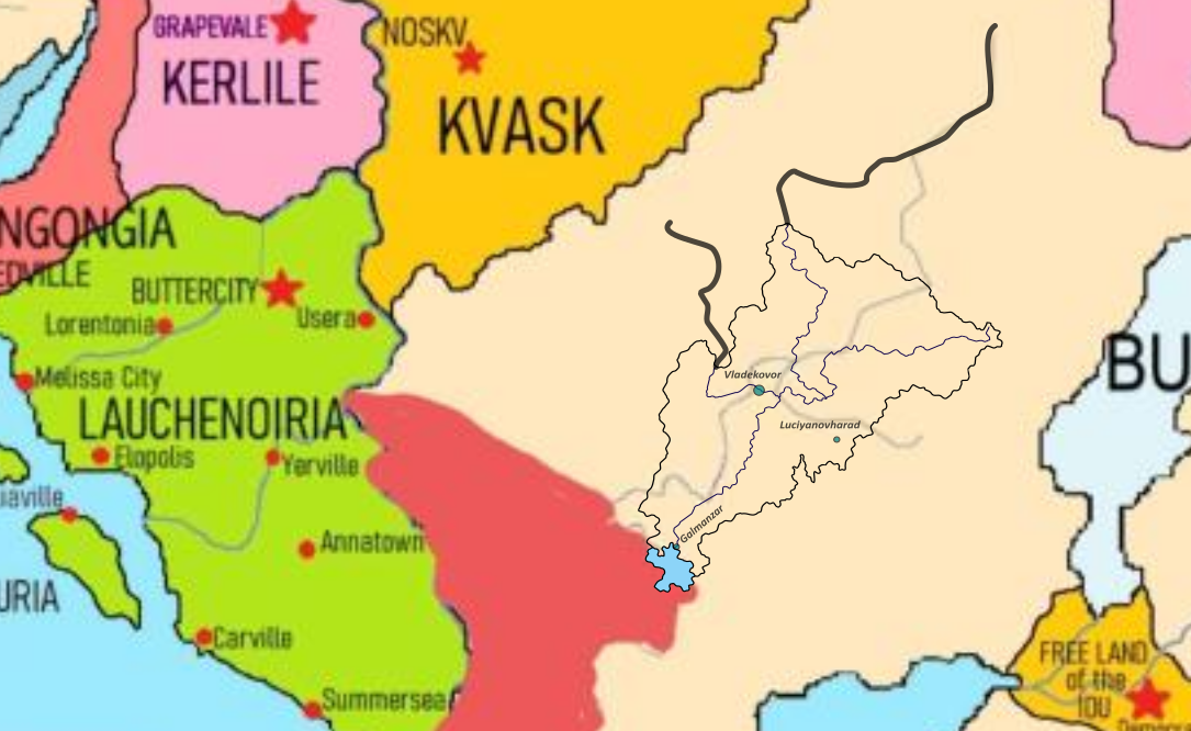
RE: IDU Ministry of Cartography 2022 Map - Regmotto - 08-26-2023
Nation Name: Regmotto Capital City: Ubilióv
Nature of request: (Please select from these options)
• Primary/Main Nation, First Time Placement
Which continent would you like to be located? (Please select from these options)
• Caxcana
Which side of the continent?
• (check below image)
Which countries are you bordering?
Ocarissa,Allied Cities,Arcadia-Dazeber,Legionas and Zamastan
Which features are characteristic of your Nation? (As many as apply)
• Large Land Area
• Riparian (many rivers)
• Jagged borders
• Lakes
• Smooth Coastline
Which color would you prefer on the Political Map?
-Teal
What real-life nation has characteristics similar to your nation in terms of size, location, geography, or culture? In terms of size,location,and geography,there isn't much of a comparision that I can think of,however my country has a Slavic majority and culture,with huge influences from Russia in that regard .
My claim(Ubilióv is the blue dot):
